Hi June, Have you seen this? The N.O.A.A. site has some better color photos of the Mavericks area sea floor on their website as well as a virtual flyover that is very cool. John Vonderlin (email John: [email protected])
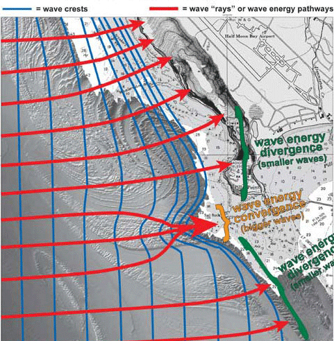
In Figure 2, the blue lines show hypothetical large wave crests propagating in to shore from the west. As the waves move into shallow water, they begin to interact with the seafloor (“shoal”) and their crests slowly bend to try to maintain their roughly parallel orientation to the bottom contours. The more the waves interact with the seafloor, the more they slow down and bunch up. Wave “rays”, or the pathways of wave energy, move perpendicular to the wave crests. In areas where the wave rays, and hence wave energy, diverges, the wave height decreases. Conversely, in areas where the wave rays, and hence wave energy, converges, the wave height increases. Due to the steep topography of the bedrock reef at Mavericks, the wave energy rapidly converges and the wave height rapidly increases, creating a huge wave compared to the adjacent areas.
The dominant wave direction off the central coast of California during most of the year is from the northwest. These waves propagate over the much gentler topography to the northwest of Sail Rock and are generally too small to shoal and break at Mavericks. Sometimes during the winter months, however, strong North Pacific storms generate large, long-period waves from more westerly directions that shoal and break over the bedrock reef just to the east of Sail Rock. The abrupt topography of the bedrock reef causes wave energy to converge over the reef, causing the wave to rapidly slow down, shorten in length and substantially increase in height relative to the areas just to the north and south of the east-west trending reef. This interaction of the geology and oceanography is what makes the wave at Mavericks so spectacular compared to many other locations along central California.

