1937: When Coastside Rentals Started at $20

 [Note: There is no correspondence leading up to this letter from R. Guy Smith, who was head of the Chamber of Commerce of San Mateo County, with headquarters in Moss Beach. We are walking into the middle of something that sounds interesting.]

Coastside Chamber of Commerce of San Mateo County

September 10, 1937

Dear Mr. Wilson,

Your letter of Sept. 6th addressed to Chamber of Commerce, Half Moon Bay has been forwarded to me [R. Guy Smith, Moss Beach.]

We do not have tract plate of the sub-divisions listed in your letter. You might be able to obtain copies from County Engineer, U.S. Marshall at Redwood City, the county seat. A full set of these maps is on file in the County Recorder’s office.

You inquired as to advisability of improving same. Just at present, houses to rent in these localities are quite limited, some people having to live as far as ten miles or more from their work. The Shell Oil Company has just recently put to work oil well drilling crews south of Half Moon Bay, these new families have just about wiped out all  available places for occupancy.

Sometime in November, it is expected that a new highway being built around Pedro Mountain, between here and San Francisco will be open for travel. This will eliminate about five miles distance to San Francisco over twelve hundred feet of climb, about 286 curves of short radius giving us a modern highway connection along the coast to San Francisco.

It is expected that this will stimulate improvement of our district by inducing more building, some for weekends, and we hope a good measure for permanent residents who will go back and forth to work at their jobs in San Francisco. Rentals are now running, I believe, from about $20.00 up per month, depending upon the type of place.

I hope this information will be of assistance to you and do not believe one could not go wrong at this time with reasonable conservative building.

Posted in Uncategorized | Comments Off on 1937: When Coastside Rentals Started at $20

Sea Urchins: The Abalone’s Enemy….

“Purple and red sea urchins images.jpeg

Strongylocentroutus purpuratus and S. francisanus, regarded as enemies of abalones, are in many areas vigorous competitors. In most localities, abalones and sea urchins are not intermixed but the edge of one population will overlap that of the other. At these contact points there is competition for food and living space. Once sea urchins have gained a foothold, they seldom leave. Although both feed on algae, sea urchins are more intensive grazers than abalones and they crop the rocks almost completely bare. When this occurs, the abalones are forced to move to another are to find food.

Continue reading

Posted in Uncategorized | Comments Off on Sea Urchins: The Abalone’s Enemy….

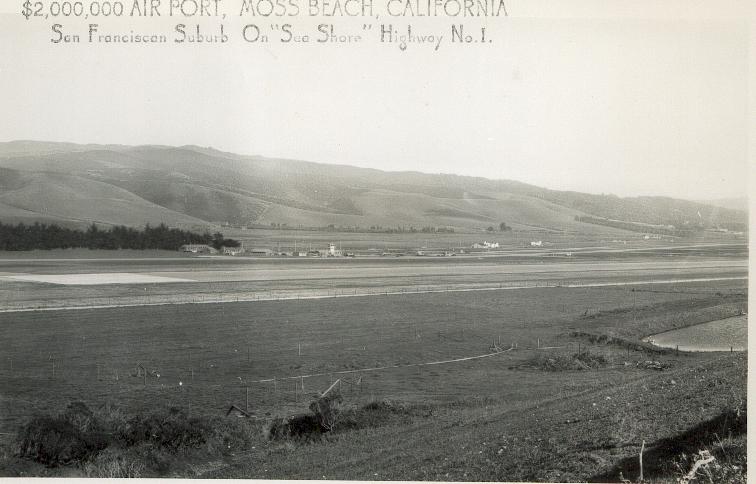
The $2 Million Airport….”San Francisco’s Suburb On ‘Sea Shore’ Highway No. 1″

airport.jpeg

Posted in Uncategorized | Comments Off on The $2 Million Airport….”San Francisco’s Suburb On ‘Sea Shore’ Highway No. 1″

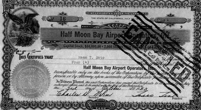
…1953: Stock Issued for HMB Airport….

airportstock10.jpg

Mr. R. Guy Smith
Secretary-Treasurer
Half Moon Bay Airport
Operator Incorporated
Moss Beach, California

Please find enclosed Stock Certificate for stock in the Half Moon Bay Airport Incorporated which I am sending as per your request as of August 23, 1955.

Please mail check to me at ……., Sharp Park, California.

Very truly yours,

Jack L. Shaw

Posted in Uncategorized | Comments Off on …1953: Stock Issued for HMB Airport….

Merry Christmas…Happy Holidays…

mcprinceton.jpeg

Posted in Uncategorized | Comments Off on Merry Christmas…Happy Holidays…

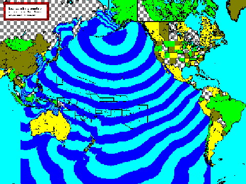
…NOAA Travel Time Map for 1946 Tidal Wave…

Time Travel Map from NOAA, click here

Each color band boundary represents a 1 hour tsunami travel time increment

traveltime55.gif

Posted in Uncategorized | Comments Off on …NOAA Travel Time Map for 1946 Tidal Wave…

April 1, 1946 Eastern Aleutian Is. Tsunami Damage…

from NOAA click here

April 1, 1946 Eastern Aleutian Is. Tsunami Damage along the Alaska, British Columbia, Washington, Oregon, and California coasts

See References for information sources.

Location Amplitude (m) Damage Summary
Unga, AK 0.8 Dock and boats washed away.
Ikatan, AK ? Several homes washed away, Pankof light destroyed.
Sanak, AK 6.1 Boats beached, some houses destroyed.
Scotch Cap, Unimak I., AK 35 Five drowned. Lighthouse destroyed. Antenna 105 feet above sea level washed away. Radio station flooded.
Dutch Harbor, AK ? Ferrys carried away, docks damaged.
Nikolski, AK up to 12.2 Nine baraboras washed away
Taholah, WA 1.5 Five foot surge up Quinalt River swamped boats and damaged fishing nets.
Seaside, OR 1.2 Boats and log float swept away in Necanicum River.
Gold Beach, OR ? Sixty-foot float endangered. Slight damage at Winchuck River.
Noyo River Mouth, CA 1.4 Many boats broke from moorings, several near drownings.
Drakes Bay, CA 2.6 Crab pots rolled over, rowboat capsized.
Princeton, CA 2.6 Much damage. Houses flooded, quarter mile inundation, boats beached, dock damaged, $20K damage.
Santa Cruz, CA 1.5 One drowned. Minor damage.
Port Hueneme, CA 0.8 Sand swept over railroad tracks.
Santa Catalina I., CA ? Baseball field inundated, pier swept away.

Posted in 1946 Tidal Wave, Princeton-by-the-Sea | Comments Off on April 1, 1946 Eastern Aleutian Is. Tsunami Damage…

…1946 Tidal Wave at Princeton….

Thank you John Vonderlin for sending this…(email John: [email protected])

From “United States Tsunamis”

1946, April 1, 12:29. A magnitude 7.8 earthquake in the Aleutian Islands generated a 30-m tsunami on Unimak Island that destroyed Scotch Cap Lighthouse. In California the tsunami caused a rise above normal tides of, 2.6 m at Half Moon Bay, 2.6 m at Bolinas, 2.4 m at Arena Cove, 1.5 m at Morro Bay, 1.5 m at Santa Cruz, 1.4 m at Noyo, 1.3 m at San Luis Obispo, and 1.2-m rise at Avila.

The Santa Cruz Sentinel reports confirm the unusual heights at Santa Cruz, and at Half Moon Bay, California. At Charleston, Oregon, near Coos Bay, 3 meter waves were observed, and 1.8 m. waves were observed at Clatsop Spit, Oregon, at the mouth of the Columbia River. The wave was 1.5 m at Newport and 1.0 m (range) at Siuslaw River. Other localities reported runups of less than 1.0 m.

At Noyo River, California, 100 fishing boats were thrown 1.8 m up bank. At Half Moon Bay where $1,000 in damage occurred waves swept into the unoccupied Coast Guard barracks loosening the building from its foundation. A house was flooded to the window sills. At nearby Princeton huge boulders weighing up to 70 kilograms were washed as far as high highway and some residences were flooded. Water was about 1 m deep on the road. A shack had a wall cave in, and it was moved 0.6 m from its foundation.

Also, at nearby Granada a 10 m boat was washed onto the highway….”

Posted in 1946 Tidal Wave, Princeton-by-the-Sea | Comments Off on …1946 Tidal Wave at Princeton….

1946: April Fool’s Tidal Wave: Coast Keeps Midnight Watch on High Tide

Tuesday, April 2, 1946

From the San Mateo Times:

“Princeton. April 2–Coastside residents today were taking the cycle of total waves in stride. Consensus of opinion was that there was nothing they could do about it, individually or collectively. After reading newspaper accounts and hearing radio reports of what happened in the Hawaiian Islands and elsewhere, local residents took the viewpoint that they were lucky with no lives lost and comparatively small property loss.

“Fearful that a high tide at midnight last night might result in more damage, a number of persons gathered at the Nerli restaurant to keep a midnight watch on the tide. Shortly after midnight, the restaurant closed and all departed.

“Several telephone calls were received at the coast guard station asking if a special watch were being kept and if a warning could be issued. Advised that Twelfth naval district orders had put the coast guard complement on the alert over night the persons, thus assured, apparently went to bed.

Continue reading

Posted in 1946 Tidal Wave, Princeton-by-the-Sea | Comments Off on 1946: April Fool’s Tidal Wave: Coast Keeps Midnight Watch on High Tide

Gray Gardner Calling…

DEAR JUNE-YOUR PRINCETON BOOK WILL ARRIVE TODAY OR MONDAY.MEANWHILE YOUR TWO EXCELLENT WEB SITES HAVE GIVEN ME MORE OF MY DAILY “COASTSIDE FIX” THAN I EVER IMAGINED RECEIVING.

I’M GLAD TO SEE TWO OLD FRIENDS,MIKE POWERS AND PETE DOUGLAS ARE STILL OUT THERE,I WILL HAVE TO LOOK THEM UP NEXT TRIP.I’M SORRY THAT RICHARD ENGLISH IS GONE,WE CALLED HIM “ORPHAN ANNE” AT THE DISTILLERY,I’LL MISS CLAY FOUNTAIN AND HIS WIFE TOO,FOR YEARS WE THOUGHT THAT THEY WERE THE LAST “WOBBLIES” (IWW) LEFT,UNTIL I FOUND OUT THE IWW IS STILL MEETING IN BERKLEY.

CLAY.ON OCCASION,USED TO PLAY HIS AUTOHARP,AT THE MIRAMAR. AND SING LABOR PROTEST SONGS.CLAY MIGHT HAVE HAD THE ONLY VOICE ON THE COASTSIDE WORSE THAN MINE.JOE DOSHER USED TO GIVE ME FREE BEER NOT TO SING ON WED. “SING ALONG NIGHTS” AT THE MIRAMAR,AS I HAD THE GIFT TO THROW A WHOLE ROOM OF DRUNKS OFF KEY.

I GOT TO THINKING AFTER MY FIRST MESSAGE TO YOU ABOUT “GENE’S BEER AND PIZZA,THAT GENE HAD PROBABLY MOVED TO OREGON BY THE TIME YOU MOVED TO EL GRANADA IN 72. By THAT TIME THE MIRAMAR,AND A YEAR LATER THE MOSS BEACH DISTILLERY HAD BECOME THE MAIN WATERING HOLES FOR THE VILLAGE LOCALS.

AS I NOTED BEFORE.I WISH I HAD SHOT MORE PICTURES OF PEOPLE AND PLACES,AND KEPT A JOURNAL.THANKS AGAIN FOR YOUR WEB SITES,THEY ARE REALLY APPRECIATED.

MERRY CHRISTMAS-GRAY GARDNER
EXCELSIOR SPRINGS,MO.12/21/07

Posted in Gray Gardner | Comments Off on Gray Gardner Calling…